Corona Arch Trail
The Corona Arch Trail near Moab offers a captivating journey through the rugged desert landscape. Hikers pass by two other notable arches, Pinto Arch and Bowtie Arch, before reaching the grand Corona Arch. Along the way, sections of slickrock, metal cables, and even a small ladder add a bit of adventure, making it a fun challenge for those comfortable with heights. Once at the arch, the views are spectacular, and the massive span of Corona Arch, set against the backdrop of the Colorado River Canyon, makes for an unforgettable sight. This relatively short trail rewards visitors with impressive geological features while providing a sense of solitude, especially compared to the more crowded national parks nearby. #Hiking #Arch #Desert #Nature #Rock
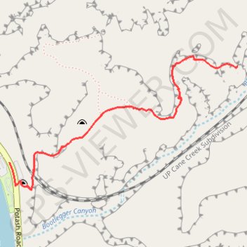
- Distance: 4.2 Km
- Elevation gain: 227 m
- Maximum elevation: 1,357 m
- Elevation loss: 228 m
- Minimum elevation: 1,210 m
Interactive trail map
Trail profile
- Distance: 4.2 Km
- Elevation gain: 227 m
- Maximum elevation: 1,357 m
- Elevation loss: 228 m
- Minimum elevation: 1,210 m
About this trail
Name: Corona Arch Trail trail, distance, elevation, map, profile, GPS track
Start: Potash Road, Grand County, Utah, United States (38.57516 -109.63300)
End: Potash Road, Grand County, Utah, United States (38.57537 -109.63312)
Coordinates: 38.57403 -109.63312 38.58054 -109.61892
Other hiking, mountain biking, running and outdoor activity trails
Click on a trail to view its statistics, map and profile.