
Council Ring, Table Rock and Crow's Nest Loop in Ledges State Park
Ledges State Park offers a scenic hiking experience that showcases the beauty of Iowa's natural landscape. The route connecting Council Ring, Table Rock, and Crow's Nest features stunning views of the Des Moines River Valley, along with the unique sandstone formations that define the park. Along the trail, hikers can enjoy the peaceful wooded areas and discover the historical significance of places like the Council Ring, making it a fulfilling outing for nature lovers and history enthusiasts alike. #Hiking #Loop #Forest #Nature
- Distance: 2.8 Km
- Elevation gain: 128 m
- Maximum elevation: 321 m
- Elevation loss: 129 m
- Minimum elevation: 265 m
- Moving time: 43 m 7 s
- Moving speed: 3.9 Km/h
- Maximum speed: 6.3 Km/h
- Total time: 43 m 7 s
- Global speed: 3.9 Km/h
Interactive trail map
Trail profile
- Distance: 2.8 Km
- Elevation gain: 128 m
- Maximum elevation: 321 m
- Elevation loss: 129 m
- Minimum elevation: 265 m
- Moving time: 43 m 7 s
- Moving speed: 3.9 Km/h
- Maximum speed: 6.3 Km/h
- Total time: 43 m 7 s
- Global speed: 3.9 Km/h
About this trail
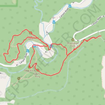
Name: Council Ring, Table Rock and Crow's Nest Loop in Ledges State Park trail, distance, elevation, map, profile, GPS track
Start: Canyon Road, Worth Township, Boone County, Iowa, United States (41.99513 -93.88038)
End: Canyon Road, Worth Township, Boone County, Iowa, United States (41.99498 -93.88087)
Coordinates: 41.99240 -93.88940 41.99559 -93.88038