Make a donation
Gear up for your next adventure:
As an Amazon Associate, this site earns from qualifying purchases at no extra cost to you.
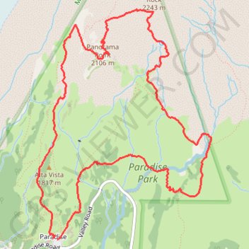
Skyline Loop Trail via Panorama Point in Mount Rainier National Park
The Skyline Loop Trail via Panorama Point in Mount Rainier National Park offers an unforgettable hiking experience characterized by breathtaking views and diverse landscapes. As you traverse the trail, you'll encounter vibrant wildflower meadows, glacial vistas, and panoramic views of iconic peaks, including Mount Rainier, Mount Adams, and Mount St. Helens on clear days. The route features a combination of steep ascents and gentle descents, allowing hikers to appreciate stunning scenery while observing local wildlife like marmots amidst the serene mountain backdrop. #Hiking #Mountain #Loop #Nature
- Distance: 9.4 Km
- Elevation gain: 581 m
- Maximum elevation: 2,143 m
- Elevation loss: 581 m
- Minimum elevation: 1,650 m
- Moving time: 2 h 16 m
- Moving speed: 4.1 Km/h
- Maximum speed: 11.0 Km/h
- Total time: 2 h 45 m
- Global speed: 3.4 Km/h
Interactive trail map
Make a donation
Gear up for your next adventure:
As an Amazon Associate, this site earns from qualifying purchases at no extra cost to you.
Trail profile
- Distance: 9.4 Km
- Elevation gain: 581 m
- Maximum elevation: 2,143 m
- Elevation loss: 581 m
- Minimum elevation: 1,650 m
- Moving time: 2 h 16 m
- Moving speed: 4.1 Km/h
- Maximum speed: 11.0 Km/h
- Total time: 2 h 45 m
- Global speed: 3.4 Km/h
Make a donation
Gear up for your next adventure:
As an Amazon Associate, this site earns from qualifying purchases at no extra cost to you.
About this trail
Name: Skyline Loop Trail via Panorama Point in Mount Rainier National Park trail, distance, elevation, map, profile, GPS track
Start: Longmire-to-Paradise Road, Paradise, Pierce County, Washington, United States (46.78611 -121.73603)
Coordinates: 46.78608 -121.73801 46.80622 -121.71576
Make a donation
Gear up for your next adventure:
As an Amazon Associate, this site earns from qualifying purchases at no extra cost to you.
Other hiking, mountain biking, running and outdoor activity trails
Click on a trail to view its statistics, map and profile.
Camp Muir via Syline Trail and Camp Muir Route in Mount Rainier National Park
United States > Washington > Pierce County > Paradise
The hike to Camp Muir via the Skyline Trail and Muir Snowfield in Mount Rainier National Park offers a breathtaking journey through vibrant wildflower meadows, rocky terrain, and expansive snowfields. As you ascend, views of nearby volcanic peaks, hanging glaciers, and ridges like Tatoosh open up, making each…
Distance: 13.5 Km • Elevation gain: 1,426 m • Maximum elevation: 3,062 m
Panorama Point Loop via Skyline Trail in Mount Rainier National Park
United States > Washington > Pierce County > Paradise
The Panorama Point Loop via Skyline Trail offers an unforgettable hiking experience in Mount Rainier National Park. Hikers are treated to spectacular panoramic views, including close-up vistas of the towering Mount Rainier, the Nisqually Glacier, and sweeping landscapes dotted with wildflowers in the summer.…
Distance: 9.0 Km • Elevation gain: 568 m • Maximum elevation: 2,143 m
Faraway Rock Loop via Mazama Ridge Trail in Mount Rainier National Park
United States > Washington > Pierce County > Paradise
The Faraway Rock Loop via Mazama Ridge Trail offers a peaceful yet rewarding hike through Mount Rainier National Park, where hikers are treated to expansive views of the surrounding wilderness. The route meanders through vibrant wildflower meadows in the summer, with stunning sights of Mount Rainier, the…
Distance: 8.4 Km • Elevation gain: 412 m • Maximum elevation: 1,763 m
Panorama Point, Golden Gate Falls and Myrtle Falls Loop
United States > Washington > Pierce County > Paradise
Loop hike from Paradise to Panorama Point via Relief Map of Mount Rainier, Skyline Trail, Dead Horse Creek Trail, Glacier Vista Trail, Glacier Vista, Upper Skyline Trail, Golden Gate Trail, Golden Gate Falls and Myrtle Falls Viewpoint in the Mount Rainier National Park and the Paradise Park. #Hiking #Loop…
Distance: 7.5 Km • Elevation gain: 536 m • Maximum elevation: 2,147 m
Make a donation
Gear up for your next adventure:
As an Amazon Associate, this site earns from qualifying purchases at no extra cost to you.
Glacier Vista via Skyline Trail in Mount Rainier National Park
United States > Washington > Pierce County > Paradise
The Glacier Vista via Skyline Trail offers breathtaking views of Mount Rainier and the Nisqually Glacier, with expansive vistas of the surrounding valleys. As hikers ascend, they will pass through wildflower meadows in the warmer months and experience dramatic alpine terrain, often encountering glaciers and…
Distance: 2.2 Km • Elevation gain: 298 m • Maximum elevation: 1,951 m
Northern part of the Pacific Crest Trail (PCT)
United States > Oregon > Klamath County
Hike on the Pacific Crest National Scenic Trail from Crater Lake to Canada Border through Oregon and Washington along the Sierra Nevada and Cascade mountain ranges. #Hiking #Mountain #SierraNevada #Cascade #Nature #Forest #Park #PCT
Distance: 1,198.3 Km • Elevation gain: 44,308 m • Maximum elevation: 2,307 m
Myrtle Falls Viewpoint via Skyline Trail
United States > Washington > Pierce County > Paradise
Distance: 2.0 Km • Elevation gain: 73 m • Maximum elevation: 1,703 m
Make a donation
Gear up for your next adventure:
As an Amazon Associate, this site earns from qualifying purchases at no extra cost to you.
Narada Falls
United States > Washington > Lewis County
Distance: 5.7 Km • Elevation gain: 323 m • Maximum elevation: 1,654 m