Thank you for supporting this site ❤️
Make a donation
Make a donation
Gear up for your next adventure:
As an Amazon Associate, this site earns from qualifying purchases at no extra cost to you.
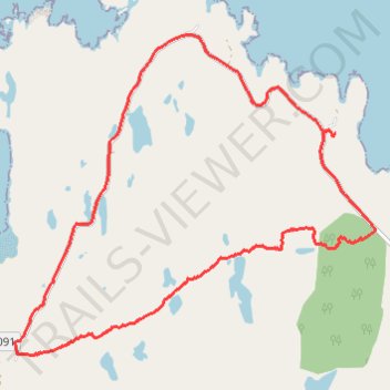
Loop hike across northern end of Applecross Peninsula
- Distance: 11.1 Km
- Elevation gain: 233 m
- Maximum elevation: 114 m
- Elevation loss: 235 m
- Minimum elevation: 15 m
Interactive trail map
Thank you for supporting this site ❤️
Make a donation
Make a donation
Gear up for your next adventure:
As an Amazon Associate, this site earns from qualifying purchases at no extra cost to you.
Trail profile
- Distance: 11.1 Km
- Elevation gain: 233 m
- Maximum elevation: 114 m
- Elevation loss: 235 m
- Minimum elevation: 15 m
Thank you for supporting this site ❤️
Make a donation
Make a donation
Gear up for your next adventure:
As an Amazon Associate, this site earns from qualifying purchases at no extra cost to you.
About this trail
Name: Loop hike across northern end of Applecross Peninsula trail, distance, elevation, map, profile, GPS track
Start: Fearnbeag Road, Fearnbeag, Highland, Scotland, IV54 8XU, United Kingdom (57.56933 -5.78658)
End: Fearnbeag Road, Fearnbeag, Highland, Scotland, IV54 8XU, United Kingdom (57.56951 -5.78638)
Coordinates: 57.55100 -5.83636 57.57782 -5.78011
Thank you for supporting this site ❤️
Make a donation
Make a donation
Gear up for your next adventure:
As an Amazon Associate, this site earns from qualifying purchases at no extra cost to you.