Thank you for supporting this site ❤️
Make a donation
Make a donation
Gear up for your next adventure:
As an Amazon Associate, this site earns from qualifying purchases at no extra cost to you.
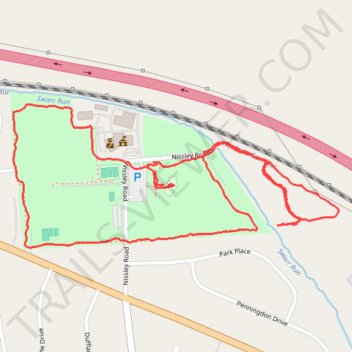
Amos Herr Park Loop
- Distance: 3.5 Km
- Elevation gain: 23 m
- Maximum elevation: 126 m
- Elevation loss: 23 m
- Minimum elevation: 109 m
- Moving time: 42 m 1 s
- Moving speed: 5.0 Km/h
- Maximum speed: 8.7 Km/h
- Total time: 42 m 1 s
- Global speed: 5.0 Km/h
Interactive trail map
Thank you for supporting this site ❤️
Make a donation
Make a donation
Gear up for your next adventure:
As an Amazon Associate, this site earns from qualifying purchases at no extra cost to you.
Trail profile
- Distance: 3.5 Km
- Elevation gain: 23 m
- Maximum elevation: 126 m
- Elevation loss: 23 m
- Minimum elevation: 109 m
- Moving time: 42 m 1 s
- Moving speed: 5.0 Km/h
- Maximum speed: 8.7 Km/h
- Total time: 42 m 1 s
- Global speed: 5.0 Km/h
Thank you for supporting this site ❤️
Make a donation
Make a donation
Gear up for your next adventure:
As an Amazon Associate, this site earns from qualifying purchases at no extra cost to you.
About this trail
Name: Amos Herr Park Loop trail, distance, elevation, map, profile, GPS track
Coordinates: 40.09302 -76.40349 40.09627 -76.39382
Thank you for supporting this site ❤️
Make a donation
Make a donation
Gear up for your next adventure:
As an Amazon Associate, this site earns from qualifying purchases at no extra cost to you.