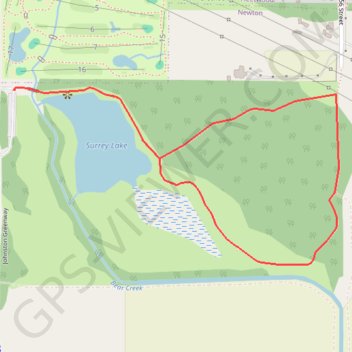
Import a GPX file

Surrey Lake Loop

#Hiking #MTB #Running #Loop

  • Distance: 2.2 Km
  • Elevation gain: 24 m
  • Maximum elevation: 23 m
  • Elevation loss: 24 m
  • Minimum elevation: 1 m

Interactive trail map

Trail profile

  • Distance: 2.2 Km
  • Elevation gain: 24 m
  • Maximum elevation: 23 m
  • Elevation loss: 24 m
  • Minimum elevation: 1 m

About this trail

Other hiking, mountain biking, running and outdoor activity trails

Click on a trail to view its statistics, map and profile.

Vancouver - Golden

Canada > British Columbia > Metro Vancouver Regional District > Vancouver

#Bike #Vancouver #Golden

Distance: 827.6 Km • Elevation gain: 9,376 m • Maximum elevation: 1,347 m

Gear up for your next adventure:

🧭GPS Handheld Device - Reliable GPS navigation for outdoor adventures
🧶550 Survival Paracord - Versatile utility cord for emergency repairs and rigging
🎒Hiking Daypack - Lightweight and durable backpacks for day trips and excursions
🧼Biodegradable Camp Soap - Environmentally friendly cleaning for gear and body
🥾Trekking Poles - Adjustable trekking poles to reduce knee stress and improve stability

As an Amazon Associate, this site earns from qualifying purchases at no extra cost to you.