Make a donation
Gear up for your next adventure:
As an Amazon Associate, this site earns from qualifying purchases at no extra cost to you.
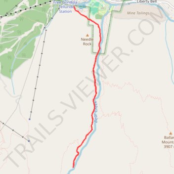
Bear Creek Falls Trail in Uncompahgre National Forest
The Bear Creek Trail, starting from Telluride, offers hikers a scenic journey through diverse landscapes. Along the way, you'll encounter dense forests, open meadows, and panoramic vistas of the surrounding rugged peaks of the San Juan Mountains. The trail culminates at the impressive Bear Creek Falls, where the cascading water provides a refreshing sight amidst the rugged terrain. #Hiking #Mountain #Forest #Nature #Waterfall
- Distance: 7.4 Km
- Elevation gain: 366 m
- Maximum elevation: 3,034 m
- Elevation loss: 373 m
- Minimum elevation: 2,679 m
- Moving time: 1 h 59 m
- Moving speed: 3.7 Km/h
- Maximum speed: 6.2 Km/h
- Total time: 2 h 39 m
- Global speed: 2.8 Km/h
Interactive trail map
Make a donation
Gear up for your next adventure:
As an Amazon Associate, this site earns from qualifying purchases at no extra cost to you.
Trail profile
- Distance: 7.4 Km
- Elevation gain: 366 m
- Maximum elevation: 3,034 m
- Elevation loss: 373 m
- Minimum elevation: 2,679 m
- Moving time: 1 h 59 m
- Moving speed: 3.7 Km/h
- Maximum speed: 6.2 Km/h
- Total time: 2 h 39 m
- Global speed: 2.8 Km/h
Make a donation
Gear up for your next adventure:
As an Amazon Associate, this site earns from qualifying purchases at no extra cost to you.
About this trail
Name: Bear Creek Falls Trail in Uncompahgre National Forest trail, distance, elevation, map, profile, GPS track
Start: Bear Creek, Telluride, San Miguel County, Colorado, 81435, United States (37.93400 -107.81171)
End: Bear Creek, Telluride, San Miguel County, Colorado, 81435, United States (37.93432 -107.81191)
Coordinates: 37.90589 -107.81208 37.93432 -107.80589
Make a donation
Gear up for your next adventure:
As an Amazon Associate, this site earns from qualifying purchases at no extra cost to you.