Make a donation
Gear up for your next adventure:
As an Amazon Associate, this site earns from qualifying purchases at no extra cost to you.
Hunter Valley Gardens - Branxton
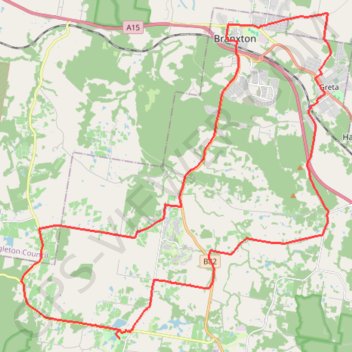
Interactive trail map
Make a donation
Gear up for your next adventure:
As an Amazon Associate, this site earns from qualifying purchases at no extra cost to you.
Trail profile
- Distance: 52.3 Km
- Elevation gain: 566 m
- Maximum elevation: 135 m
- Elevation loss: 578 m
- Minimum elevation: 29 m
Make a donation
Gear up for your next adventure:
As an Amazon Associate, this site earns from qualifying purchases at no extra cost to you.
About this trail
Name: Hunter Valley Gardens - Branxton trail, distance, elevation, map, profile, GPS track
Coordinates: -32.77575 151.25295 -32.65129 151.39371
Make a donation
Gear up for your next adventure:
As an Amazon Associate, this site earns from qualifying purchases at no extra cost to you.
Other hiking, mountain biking, running and outdoor activity trails
Click on a trail to view its statistics, map and profile.
Broadmeadow - Gulgong - Merrygoen - Dubbo railway
Australia > New South Wales > Newcastle
AU, NSW, railway
Distance: 374.4 Km • Elevation gain: 2,635 m • Maximum elevation: 504 m
Broadmeadow - Gulgong - Merrygoen - Dubbo railway
Australia > New South Wales > Newcastle
AU, NSW, railway
Distance: 375.3 Km • Elevation gain: 2,641 m • Maximum elevation: 517 m