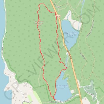
Norumbega Mountain Loop
Loop hike to Norumbega Mountain via Goat Trail, Norumbega Mountain Trail, Hadlock Lower Dam, Hadlock Ponds Trail, Lower Hadlock Pond and Lower Norumbega Trail in the Acadia National Park on the Mount Desert Island. #Hiking #Loop #Mountain #Lake #Island #Park #Nature
- Distance: 5.2 Km
- Elevation gain: 234 m
- Maximum elevation: 251 m
- Elevation loss: 235 m
- Minimum elevation: 58 m
- Moving time: 1 h 30 m
- Moving speed: 3.5 Km/h
- Maximum speed: 5.5 Km/h
- Total time: 1 h 30 m
- Global speed: 3.5 Km/h
Interactive trail map
Trail profile
- Distance: 5.2 Km
- Elevation gain: 234 m
- Maximum elevation: 251 m
- Elevation loss: 235 m
- Minimum elevation: 58 m
- Moving time: 1 h 30 m
- Moving speed: 3.5 Km/h
- Maximum speed: 5.5 Km/h
- Total time: 1 h 30 m
- Global speed: 3.5 Km/h
About this trail
Name: Norumbega Mountain Loop trail, distance, elevation, map, profile, GPS track
Start: Sound Drive, Asticou, Mount Desert, Hancock County, Maine, United States (44.32540 -68.29122)
End: Hadlock Brook Trail, Mount Desert, Hancock County, Maine, United States (44.32536 -68.29110)
Coordinates: 44.30865 -68.29649 44.32750 -68.28830