Make a donation
Gear up for your next adventure:
As an Amazon Associate, this site earns from qualifying purchases at no extra cost to you.
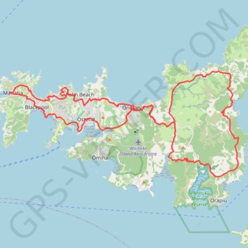
Waiheke Island Bike Loop
Loop bike around Waiheke Island from Matiatia Bay via Oneroa, Palm Beach, Onetangi, Man o'War Bay, Te Matuku Bay, Ostend, Surfdale and Blackpool. #Bike #Loop #Waiheke #Island #Nature #Sea #Pacific #Ocean #Forest #Countryside
- Distance: 61.8 Km
- Elevation gain: 1,696 m
- Maximum elevation: 148 m
- Elevation loss: 1,697 m
- Minimum elevation: 0 m
- Moving time: 5 h 50 m
- Moving speed: 10.6 Km/h
- Maximum speed: 63.0 Km/h
- Total time: 9 h 51 m
- Global speed: 6.3 Km/h
Interactive trail map
Make a donation
Gear up for your next adventure:
As an Amazon Associate, this site earns from qualifying purchases at no extra cost to you.
Trail profile
- Distance: 61.8 Km
- Elevation gain: 1,696 m
- Maximum elevation: 148 m
- Elevation loss: 1,697 m
- Minimum elevation: 0 m
- Moving time: 5 h 50 m
- Moving speed: 10.6 Km/h
- Maximum speed: 63.0 Km/h
- Total time: 9 h 51 m
- Global speed: 6.3 Km/h
Make a donation
Gear up for your next adventure:
As an Amazon Associate, this site earns from qualifying purchases at no extra cost to you.
About this trail
Name: Waiheke Island Bike Loop trail, distance, elevation, map, profile, GPS track
Start: Mātiatia Wharf, Ocean View Road, Matiatia, Waiheke, Auckland, New Zealand (-36.78043 174.99254)
Coordinates: -36.82971 174.99235 -36.76811 175.15956
Make a donation
Gear up for your next adventure:
As an Amazon Associate, this site earns from qualifying purchases at no extra cost to you.