Import a GPX file

Gordon River Road

Southwest National Park. #Bike #Southwest #Tasmania

  • Distance: 43.3 Km
  • Elevation gain: 1,192 m
  • Maximum elevation: 595 m
  • Elevation loss: 1,022 m
  • Minimum elevation: 305 m

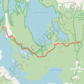
Interactive trail map

Trail profile

  • Distance: 43.3 Km
  • Elevation gain: 1,192 m
  • Maximum elevation: 595 m
  • Elevation loss: 1,022 m
  • Minimum elevation: 305 m

About this trail

Name: Gordon River Road trail, distance, elevation, map, profile, GPS track

Start: Pedder Wilderness Lodge, Olga Street, Strathgordon, Derwent Valley, Tasmania, 7139, Australia (-42.76860 146.04614)

End: Gordon River Road, Maydena, Derwent Valley, Tasmania, 7140, Australia (-42.81365 146.38567)

Coordinates: -42.86264 146.04465 -42.76547 146.38567

Gear up for your next adventure:

🔭Compact Binoculars - Lightweight optics for scouting trails and wildlife
🥾Durable Hiking Shoes - Long-lasting shoes for frequent hiking
🔭Compact Monocular - One-handed bird watching and trail spotting
🥾Lightweight Hiking Boots - Boots for comfort and mobility on long hikes
🧢Hiking Sun Hat - Wide-brimmed protection for exposed mountain ridges

As an Amazon Associate, this site earns from qualifying purchases at no extra cost to you.