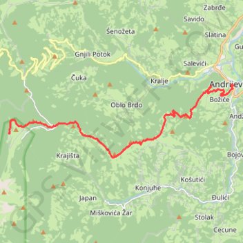
MNE-10: Katun Kobil do (Komovi) - Andrijevica
- Distance: 15.6 Km
- Elevation gain: 180 m
- Maximum elevation: 1,772 m
- Elevation loss: 1,136 m
- Minimum elevation: 778 m
- Moving time: 4 h 2 m
- Moving speed: 3.9 Km/h
- Maximum speed: 7.0 Km/h
- Total time: 6 h 36 s
- Global speed: 2.6 Km/h
Interactive trail map
Trail profile
- Distance: 15.6 Km
- Elevation gain: 180 m
- Maximum elevation: 1,772 m
- Elevation loss: 1,136 m
- Minimum elevation: 778 m
- Moving time: 4 h 2 m
- Moving speed: 3.9 Km/h
- Maximum speed: 7.0 Km/h
- Total time: 6 h 36 s
- Global speed: 2.6 Km/h
About this trail
Name: MNE-10: Katun Kobil do (Komovi) - Andrijevica trail, distance, elevation, map, profile, GPS track
Start: Kobil do, Katun Kobil do, Andrijevica Municipality, Montenegro (42.71492 19.67734)
Coordinates: 42.70555 19.67734 42.73320 19.79308
Other hiking, mountain biking, running and outdoor activity trails
Click on a trail to view its statistics, map and profile.
2022_Yu
Slovenia > Ajdovščina > Žapuže
Distance: 2,457.3 Km • Elevation gain: 32,048 m • Maximum elevation: 1,950 m
10-JUL-09
Montenegro > Andrijevica Municipality > Katun Božića
Distance: 15.2 Km • Elevation gain: 1,402 m • Maximum elevation: 2,443 m