Make a donation
Gear up for your next adventure:
As an Amazon Associate, this site earns from qualifying purchases at no extra cost to you.
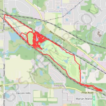
Creekside Trails
- Distance: 28.2 Km
- Elevation gain: 229 m
- Maximum elevation: 220 m
- Elevation loss: 229 m
- Minimum elevation: 202 m
Interactive trail map
Make a donation
Gear up for your next adventure:
As an Amazon Associate, this site earns from qualifying purchases at no extra cost to you.
Trail profile
- Distance: 28.2 Km
- Elevation gain: 229 m
- Maximum elevation: 220 m
- Elevation loss: 229 m
- Minimum elevation: 202 m
Make a donation
Gear up for your next adventure:
As an Amazon Associate, this site earns from qualifying purchases at no extra cost to you.
About this trail
Name: Creekside Trails trail, distance, elevation, map, profile, GPS track
Start: North 150 West, Valparaiso, Porter County, Indiana, 46383, United States (41.47988 -87.09528)
End: North 150 West, Valparaiso, Porter County, Indiana, 46383, United States (41.47982 -87.09527)
Coordinates: 41.46880 -87.11424 41.48792 -87.08170
Make a donation
Gear up for your next adventure:
As an Amazon Associate, this site earns from qualifying purchases at no extra cost to you.
Other hiking, mountain biking, running and outdoor activity trails
Click on a trail to view its statistics, map and profile.
Creekside Trails
United States > Indiana > Porter County > Valparaiso
Mountain Biking
Distance: 20.8 Km • Elevation gain: 133 m • Maximum elevation: 249 m