Import a GPX file

Sycamore Falls

  • Distance: 5.9 Km
  • Elevation gain: 209 m
  • Maximum elevation: 350 m
  • Elevation loss: 209 m
  • Minimum elevation: 244 m
  • Moving time: 1 h 35 m
  • Moving speed: 3.7 Km/h
  • Maximum speed: 5.7 Km/h
  • Total time: 2 h 14 m
  • Global speed: 2.6 Km/h

Interactive trail map

Trail profile

  • Distance: 5.9 Km
  • Elevation gain: 209 m
  • Maximum elevation: 350 m
  • Elevation loss: 209 m
  • Minimum elevation: 244 m
  • Moving time: 1 h 35 m
  • Moving speed: 3.7 Km/h
  • Maximum speed: 5.7 Km/h
  • Total time: 2 h 14 m
  • Global speed: 2.6 Km/h

About this trail
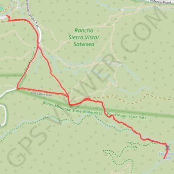
Name: Sycamore Falls trail, distance, elevation, map, profile, GPS track

Start: Pinehill Trail, Thousand Oaks, Ventura County, California, 91320, United States (34.15296 -118.96519)

End: Pinehill Trail, Thousand Oaks, Ventura County, California, 91320, United States (34.15305 -118.96545)

Coordinates: 34.13975 -118.96545 34.15305 -118.94738

Gear up for your next adventure:

🐕Hiking Dog Pack - Let your canine companion carry their own water and food
🥾Trail Hiking Socks - Comfortable socks to prevent blisters and fatigue
🧢Beanie Hat - Keep your head warm in cold weather
🥤Collapsible Travel Cup - Saves space and weight in your mess kit
🧴Sunscreen SPF - Broad-spectrum sunscreen for outdoor activities

As an Amazon Associate, this site earns from qualifying purchases at no extra cost to you.