Thank you for supporting this site ❤️
Make a donation
Make a donation
Gear up for your next adventure:
As an Amazon Associate, this site earns from qualifying purchases at no extra cost to you.
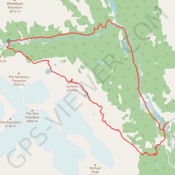
Iceline Trail - Takakkaw Falls
Interactive trail map
Thank you for supporting this site ❤️
Make a donation
Make a donation
Gear up for your next adventure:
As an Amazon Associate, this site earns from qualifying purchases at no extra cost to you.
Trail profile
- Distance: 20.6 Km
- Elevation gain: 881 m
- Maximum elevation: 2,226 m
- Elevation loss: 881 m
- Minimum elevation: 1,506 m
Thank you for supporting this site ❤️
Make a donation
Make a donation
Gear up for your next adventure:
As an Amazon Associate, this site earns from qualifying purchases at no extra cost to you.
About this trail
Name: Iceline Trail - Takakkaw Falls trail, distance, elevation, map, profile, GPS track
Coordinates: 51.48733 -116.56509 51.53279 -116.47793
Topography: Area A (Kicking Horse/Kinbasket Lake) topographic map, elevation, terrain
Thank you for supporting this site ❤️
Make a donation
Make a donation
Gear up for your next adventure:
As an Amazon Associate, this site earns from qualifying purchases at no extra cost to you.
Other hiking, mountain biking, running and outdoor activity trails
Click on a trail to view its statistics, map and profile.