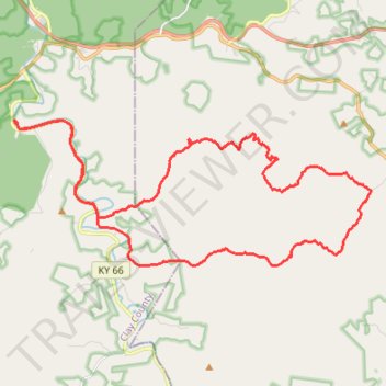
Redbird WMA Gravel Ride
- Distance: 37.4 Km
- Elevation gain: 736 m
- Maximum elevation: 473 m
- Elevation loss: 737 m
- Minimum elevation: 257 m
- Moving time: 3 h 1 m
- Moving speed: 12.3 Km/h
- Maximum speed: 40.5 Km/h
- Total time: 3 h 28 m
- Global speed: 10.7 Km/h
Interactive trail map
Trail profile
- Distance: 37.4 Km
- Elevation gain: 736 m
- Maximum elevation: 473 m
- Elevation loss: 737 m
- Minimum elevation: 257 m
- Moving time: 3 h 1 m
- Moving speed: 12.3 Km/h
- Maximum speed: 40.5 Km/h
- Total time: 3 h 28 m
- Global speed: 10.7 Km/h
About this trail
Name: Redbird WMA Gravel Ride trail, distance, elevation, map, profile, GPS track
Start: Frank Bowling Road, Peabody, Clay County, Kentucky, 40914, United States (37.14140 -83.59199)
End: Frank Bowling Road, Peabody, Clay County, Kentucky, 40914, United States (37.14133 -83.59204)
Coordinates: 37.10177 -83.59319 37.14258 -83.46839