Thank you for supporting this site ❤️
Make a donation
Make a donation
Gear up for your next adventure:
As an Amazon Associate, this site earns from qualifying purchases at no extra cost to you.
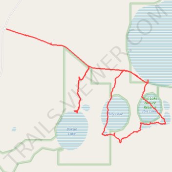
Ibis Lake circuit
- Distance: 11.6 Km
- Elevation gain: 36 m
- Maximum elevation: 315 m
- Elevation loss: 21 m
- Minimum elevation: 293 m
- Moving time: 2 h 10 m
- Moving speed: 5.3 Km/h
- Maximum speed: 34.7 Km/h
- Total time: 3 h 6 m
- Global speed: 3.7 Km/h
Interactive trail map
Thank you for supporting this site ❤️
Make a donation
Make a donation
Gear up for your next adventure:
As an Amazon Associate, this site earns from qualifying purchases at no extra cost to you.
Trail profile
- Distance: 11.6 Km
- Elevation gain: 36 m
- Maximum elevation: 315 m
- Elevation loss: 21 m
- Minimum elevation: 293 m
- Moving time: 2 h 10 m
- Moving speed: 5.3 Km/h
- Maximum speed: 34.7 Km/h
- Total time: 3 h 6 m
- Global speed: 3.7 Km/h
Thank you for supporting this site ❤️
Make a donation
Make a donation
Gear up for your next adventure:
As an Amazon Associate, this site earns from qualifying purchases at no extra cost to you.
About this trail
Name: Ibis Lake circuit trail, distance, elevation, map, profile, GPS track
Start: Lakes Road, Nomans Lake, Shire Of Narrogin, Western Australia, Australia (-32.98314 117.54292)
End: Lakes Road, Nomans Lake, Shire Of Narrogin, Western Australia, Australia (-32.97296 117.51081)
Coordinates: -32.99458 117.51081 -32.97296 117.54686
Thank you for supporting this site ❤️
Make a donation
Make a donation
Gear up for your next adventure:
As an Amazon Associate, this site earns from qualifying purchases at no extra cost to you.