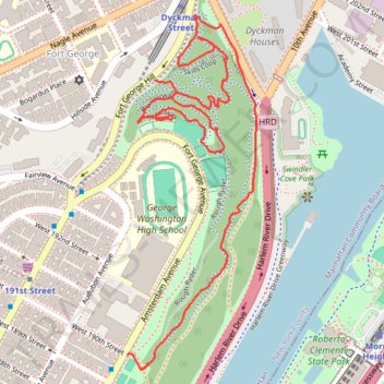
To the top of Manhattan
- Distance: 2.6 Km
- Elevation gain: 71 m
- Maximum elevation: 63 m
- Elevation loss: 99 m
- Minimum elevation: 9 m
- Moving time: 39 m 44 s
- Moving speed: 4.0 Km/h
- Maximum speed: 30.7 Km/h
- Total time: 40 m 25 s
- Global speed: 3.9 Km/h
Interactive trail map
Trail profile
- Distance: 2.6 Km
- Elevation gain: 71 m
- Maximum elevation: 63 m
- Elevation loss: 99 m
- Minimum elevation: 9 m
- Moving time: 39 m 44 s
- Moving speed: 4.0 Km/h
- Maximum speed: 30.7 Km/h
- Total time: 40 m 25 s
- Global speed: 3.9 Km/h
About this trail
Name: To the top of Manhattan trail, distance, elevation, map, profile, GPS track
Coordinates: 40.85337 -73.92671 40.86074 -73.92317
Other hiking, mountain biking, running and outdoor activity trails
Click on a trail to view its statistics, map and profile.
Old Croton Aqueduct Trail and Bronx
United States > New York > Westchester County > Village of Croton-on-Hudson
Distance: 70.8 Km • Elevation gain: 823 m • Maximum elevation: 80 m