Thank you for supporting this site ❤️
Make a donation
Make a donation
Gear up for your next adventure:
As an Amazon Associate, this site earns from qualifying purchases at no extra cost to you.
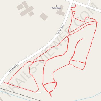
Jack Smith Creek Wetlands Trail
- Distance: 4.5 Km
- Elevation gain: 12 m
- Maximum elevation: 3 m
- Elevation loss: 12 m
- Minimum elevation: -3 m
- Moving time: 57 m 24 s
- Moving speed: 4.7 Km/h
- Maximum speed: 8.1 Km/h
- Total time: 58 m 8 s
- Global speed: 4.7 Km/h
Interactive trail map
Thank you for supporting this site ❤️
Make a donation
Make a donation
Gear up for your next adventure:
As an Amazon Associate, this site earns from qualifying purchases at no extra cost to you.
Trail profile
- Distance: 4.5 Km
- Elevation gain: 12 m
- Maximum elevation: 3 m
- Elevation loss: 12 m
- Minimum elevation: -3 m
- Moving time: 57 m 24 s
- Moving speed: 4.7 Km/h
- Maximum speed: 8.1 Km/h
- Total time: 58 m 8 s
- Global speed: 4.7 Km/h
Thank you for supporting this site ❤️
Make a donation
Make a donation
Gear up for your next adventure:
As an Amazon Associate, this site earns from qualifying purchases at no extra cost to you.
About this trail
Name: Jack Smith Creek Wetlands Trail trail, distance, elevation, map, profile, GPS track
Coordinates: 35.12194 -77.06741 35.12745 -77.06058
Thank you for supporting this site ❤️
Make a donation
Make a donation
Gear up for your next adventure:
As an Amazon Associate, this site earns from qualifying purchases at no extra cost to you.