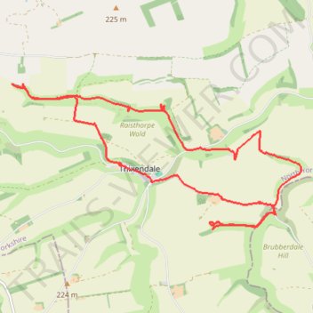
Thixendale Loop
- Distance: 15.3 Km
- Elevation gain: 396 m
- Maximum elevation: 211 m
- Elevation loss: 397 m
- Minimum elevation: 106 m
- Moving time: 2 h 3 m
- Moving speed: 7.4 Km/h
- Maximum speed: 14.1 Km/h
- Total time: 2 h 7 m
- Global speed: 7.2 Km/h
Interactive trail map
Trail profile
- Distance: 15.3 Km
- Elevation gain: 396 m
- Maximum elevation: 211 m
- Elevation loss: 397 m
- Minimum elevation: 106 m
- Moving time: 2 h 3 m
- Moving speed: 7.4 Km/h
- Maximum speed: 14.1 Km/h
- Total time: 2 h 7 m
- Global speed: 7.2 Km/h
About this trail
Name: Thixendale Loop trail, distance, elevation, map, profile, GPS track
Coordinates: 54.03086 -0.74383 54.05099 -0.67570
Other hiking, mountain biking, running and outdoor activity trails
Click on a trail to view its statistics, map and profile.
Fridaythorpe Loop Trail Running
United Kingdom > England > East Riding of Yorkshire > Fridaythorpe
Distance: 15.6 Km • Elevation gain: 269 m • Maximum elevation: 216 m
East Riding of Yorkshire Trail Running
United Kingdom > England > East Riding of Yorkshire
Distance: 33.5 Km • Elevation gain: 505 m • Maximum elevation: 235 m
Acklam loop
United Kingdom > England > North Yorkshire > Norton-on-Derwent
Distance: 34.8 Km • Elevation gain: 551 m • Maximum elevation: 237 m