Make a donation
Gear up for your next adventure:
As an Amazon Associate, this site earns from qualifying purchases at no extra cost to you.
Montmin-Balmettes-Solliet
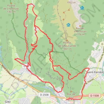
- Distance: 28.1 Km
- Elevation gain: 1,724 m
- Maximum elevation: 1,168 m
- Elevation loss: 1,710 m
- Minimum elevation: 482 m
Interactive trail map
Make a donation
Gear up for your next adventure:
As an Amazon Associate, this site earns from qualifying purchases at no extra cost to you.
Trail profile
- Distance: 28.1 Km
- Elevation gain: 1,724 m
- Maximum elevation: 1,168 m
- Elevation loss: 1,710 m
- Minimum elevation: 482 m
Make a donation
Gear up for your next adventure:
As an Amazon Associate, this site earns from qualifying purchases at no extra cost to you.
About this trail
Name: Montmin-Balmettes-Solliet trail, distance, elevation, map, profile, GPS track
Coordinates: 45.75346 6.25208 45.79809 6.30160
Make a donation
Gear up for your next adventure:
As an Amazon Associate, this site earns from qualifying purchases at no extra cost to you.
Other hiking, mountain biking, running and outdoor activity trails
Click on a trail to view its statistics, map and profile.
Montmin-Balmettes-Solliet
France > Auvergne-Rhône-Alpes > Upper Savoy > Faverges-Seythenex
Distance: 29.6 Km • Elevation gain: 1,730 m • Maximum elevation: 1,168 m
Dag 3: Forclaz - Aravis
France > Auvergne-Rhône-Alpes > Upper Savoy > Le Grand-Bornand > Le Mont
Distance: 103.0 Km • Elevation gain: 2,932 m • Maximum elevation: 1,488 m
PT23DS2 Lörrach → Cadaqués
Germany > Baden-Württemberg > Landkreis Lörrach > Lörrach (Kernstadt)
Distance: 1,050.7 Km • Elevation gain: 13,130 m • Maximum elevation: 1,505 m