Thank you for supporting this site ❤️
Make a donation
Make a donation
Gear up for your next adventure:
As an Amazon Associate, this site earns from qualifying purchases at no extra cost to you.
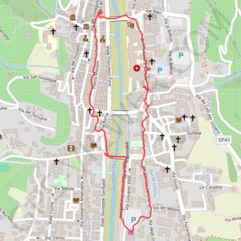
28/05/2022 17:14
- Distance: 2.2 Km
- Elevation gain: 21 m
- Maximum elevation: 75 m
- Elevation loss: 22 m
- Minimum elevation: 54 m
- Moving time: 28 m 55 s
- Moving speed: 4.6 Km/h
- Maximum speed: 15.7 Km/h
- Total time: 57 m 35 s
- Global speed: 2.3 Km/h
Interactive trail map
Thank you for supporting this site ❤️
Make a donation
Make a donation
Gear up for your next adventure:
As an Amazon Associate, this site earns from qualifying purchases at no extra cost to you.
Trail profile
- Distance: 2.2 Km
- Elevation gain: 21 m
- Maximum elevation: 75 m
- Elevation loss: 22 m
- Minimum elevation: 54 m
- Moving time: 28 m 55 s
- Moving speed: 4.6 Km/h
- Maximum speed: 15.7 Km/h
- Total time: 57 m 35 s
- Global speed: 2.3 Km/h
Thank you for supporting this site ❤️
Make a donation
Make a donation
Gear up for your next adventure:
As an Amazon Associate, this site earns from qualifying purchases at no extra cost to you.
About this trail
Name: 28/05/2022 17:14 trail, distance, elevation, map, profile, GPS track
Coordinates: 43.89794 10.68830 43.90527 10.69110
Thank you for supporting this site ❤️
Make a donation
Make a donation
Gear up for your next adventure:
As an Amazon Associate, this site earns from qualifying purchases at no extra cost to you.
Other hiking, mountain biking, running and outdoor activity trails
Click on a trail to view its statistics, map and profile.
1 LUCENA - MONTPELLIER
Distance: 2,964.4 Km • Elevation gain: 29,500 m • Maximum elevation: 1,048 m