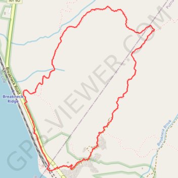
Breakneck Trails Loop
Interactive trail map
Trail profile
- Distance: 5.1 Km
- Elevation gain: 375 m
- Maximum elevation: 364 m
- Elevation loss: 375 m
- Minimum elevation: 3 m
About this trail
Name: Breakneck Trails Loop trail, distance, elevation, map, profile, GPS track
Coordinates: 41.44236 -73.98057 41.45583 -73.96623
Other hiking, mountain biking, running and outdoor activity trails
Click on a trail to view its statistics, map and profile.
Bull Hill Short Loop
United States > New York > Putnam County
Starting near Little Stony Point and Cold Spring, the Bull Hill Short Loop climbs from the Washburn Trailhead through woods toward the old quarry and early Hudson River viewpoints. The route then follows the Undercliff Trail across the shoulder of Bull Hill, passing rock outcrops with views over the Hudson…
Distance: 7.1 Km • Elevation gain: 375 m • Maximum elevation: 338 m
Bull Hill Short Loop via Undercliff Trail in Hudson Highlands State Park Preserve
United States > New York > Putnam County
The Bull Hill Short Loop via the Undercliff Trail in Hudson Highlands State Park Preserve offers hikers captivating vistas of the Hudson River, with clear views of Storm King Mountain and Breakneck Ridge. Along the trail, remnants of the historic Cornish Estate provide a glimpse into the area's past. The path…
Distance: 7.1 Km • Elevation gain: 374 m • Maximum elevation: 338 m
Bull Hill Loop in Hudson Highlands State Park
United States > New York > Putnam County
The Bull Hill Loop offers a scenic and varied hike, with diverse viewpoints over the Hudson River and surrounding highlands. The trail provides steady elevation that can be challenging, but hikers are rewarded with lookouts toward Storm King Mountain, the village of Cold Spring, and even the distant New York…
Distance: 8.7 Km • Elevation gain: 426 m • Maximum elevation: 421 m
Breakneck Ridge Loop via Breakneck Ridge Trail, Breakneck Bypass Trail and Wilkinson Trail in Hudson Highlands State Park Preserve
United States > New York > Dutchess County > Town of Fishkill > Dutchess Junction
The Breakneck Ridge Loop is a thrilling hiking adventure, characterized by its steep ascents and exhilarating rock scrambles. Along the route, hikers are treated to spectacular panoramic views of the Hudson River and surrounding mountains, particularly at the Flagpole area and other scenic points. The trail…
Distance: 5.1 Km • Elevation gain: 380 m • Maximum elevation: 364 m
Cornish Trail from trailhead to Undercliff Trail Junction (upper) as well as Undercliff Trail from Cornish Trail Junction (upper) to Breakneck-view point
United States > New York > Putnam County
Hudson Highlands State Park, Cornish Trail, Undercliff Trail, Bull Hill
Distance: 10.1 Km • Elevation gain: 398 m • Maximum elevation: 338 m
Hudson Highlands State Park - Breakneck Ridge Trail, Undercliff Trail and Brook Trail
United States > New York > Dutchess County > City of Beacon
Description:
Distance: 3.5 Km • Elevation gain: 274 m • Maximum elevation: 270 m