Thank you for supporting this site ❤️
Make a donation
Make a donation
Gear up for your next adventure:
As an Amazon Associate, this site earns from qualifying purchases at no extra cost to you.
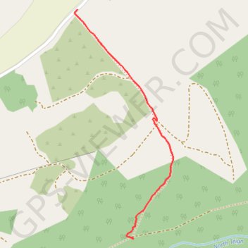
Forest path in Gidleigh #2
- Distance: 0.8 Km
- Elevation gain: 43 m
- Maximum elevation: 306 m
- Elevation loss: 30 m
- Minimum elevation: 262 m
- Moving time: 15 m 8 s
- Moving speed: 3.0 Km/h
- Maximum speed: 7.8 Km/h
- Total time: 27 m
- Global speed: 1.7 Km/h
Interactive trail map
Thank you for supporting this site ❤️
Make a donation
Make a donation
Gear up for your next adventure:
As an Amazon Associate, this site earns from qualifying purchases at no extra cost to you.
Trail profile
- Distance: 0.8 Km
- Elevation gain: 43 m
- Maximum elevation: 306 m
- Elevation loss: 30 m
- Minimum elevation: 262 m
- Moving time: 15 m 8 s
- Moving speed: 3.0 Km/h
- Maximum speed: 7.8 Km/h
- Total time: 27 m
- Global speed: 1.7 Km/h
Thank you for supporting this site ❤️
Make a donation
Make a donation
Gear up for your next adventure:
As an Amazon Associate, this site earns from qualifying purchases at no extra cost to you.
About this trail
Name: Forest path in Gidleigh #2 trail, distance, elevation, map, profile, GPS track
Start: Teigncombe, Chagford, West Devon, Devon, England, TQ13 8ET, United Kingdom (50.67352 -3.87947)
End: Gidleigh, West Devon, Devon, England, TQ13 8HS, United Kingdom (50.67866 -3.88143)
Coordinates: 50.67348 -3.88153 50.67866 -3.87802
Thank you for supporting this site ❤️
Make a donation
Make a donation
Gear up for your next adventure:
As an Amazon Associate, this site earns from qualifying purchases at no extra cost to you.