Thank you for supporting this site ❤️
Make a donation
Make a donation
Gear up for your next adventure:
As an Amazon Associate, this site earns from qualifying purchases at no extra cost to you.
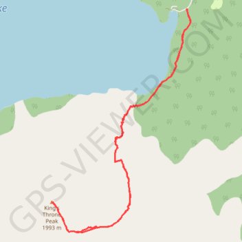
Kings Throne Summit Hike in Kluane Park Yukon Canada
- Distance: 13.4 Km
- Elevation gain: 1,312 m
- Maximum elevation: 2,004 m
- Elevation loss: 1,312 m
- Minimum elevation: 740 m
- Moving time: 5 h 19 m
- Moving speed: 2.5 Km/h
- Maximum speed: 6.7 Km/h
- Total time: 8 h 13 m
- Global speed: 1.6 Km/h
Interactive trail map
Thank you for supporting this site ❤️
Make a donation
Make a donation
Gear up for your next adventure:
As an Amazon Associate, this site earns from qualifying purchases at no extra cost to you.
Trail profile
- Distance: 13.4 Km
- Elevation gain: 1,312 m
- Maximum elevation: 2,004 m
- Elevation loss: 1,312 m
- Minimum elevation: 740 m
- Moving time: 5 h 19 m
- Moving speed: 2.5 Km/h
- Maximum speed: 6.7 Km/h
- Total time: 8 h 13 m
- Global speed: 1.6 Km/h
Thank you for supporting this site ❤️
Make a donation
Make a donation
Gear up for your next adventure:
As an Amazon Associate, this site earns from qualifying purchases at no extra cost to you.
About this trail
Name: Kings Throne Summit Hike in Kluane Park Yukon Canada trail, distance, elevation, map, profile, GPS track
Start: King's Throne Trail, Yukon, Canada (60.57628 -137.21781)
End: King's Throne Trail, Yukon, Canada (60.57631 -137.21811)
Coordinates: 60.54212 -137.26009 60.57638 -137.21680
Topography: Yukon topographic map, elevation, terrain
Thank you for supporting this site ❤️
Make a donation
Make a donation
Gear up for your next adventure:
As an Amazon Associate, this site earns from qualifying purchases at no extra cost to you.