Saint Mary's Glacier
Interactive trail map
Trail profile
- Distance: 4.0 Km
- Elevation gain: 321 m
- Maximum elevation: 3,493 m
- Elevation loss: 322 m
- Minimum elevation: 3,171 m
About this trail
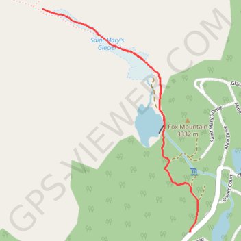
Name: Saint Mary's Glacier trail, distance, elevation, map, profile, GPS track
Start: 599, Saint Mary's Drive, Clear Creek County, Colorado, 80452, United States (39.82704 -105.64345)
End: 598, Saint Mary's Drive, Clear Creek County, Colorado, 80452, United States (39.82704 -105.64341)
Coordinates: 39.82704 -105.65370 39.83899 -105.64287
Other hiking, mountain biking, running and outdoor activity trails
Click on a trail to view its statistics, map and profile.
Saint Mary's Lake and Saint Mary's Glacier in Arapaho National Forest
United States > Colorado > Clear Creek County
The hike to Saint Mary's Glacier is a fantastic choice for anyone looking to enjoy some stunning mountain views without a super long trek. You’ll find a lovely alpine lake early on, and if you're up for it, heading a bit higher offers even better scenery. Plus, spotting moose along the way adds a nice touch…
Distance: 3.1 Km • Elevation gain: 159 m • Maximum elevation: 3,311 m