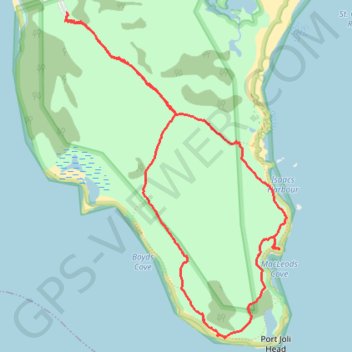
Import a GPX file
👉 Easily get elevation data in JSON, GeoTIFF and KML formats using Elevation API
Thank you for supporting this site ❤️
Make a donation

Gear up for your next adventure:

As an Amazon Associate, this site earns from qualifying purchases at no extra cost to you.

Port Joli Head Loop

#Hiking #Walking #Bike

  • Distance: 8.1 Km
  • Elevation gain: 56 m
  • Maximum elevation: 33 m
  • Elevation loss: 56 m
  • Minimum elevation: 0 m
  • Moving time: 1 h 39 m
  • Moving speed: 4.9 Km/h
  • Maximum speed: 9.6 Km/h
  • Total time: 1 h 47 m
  • Global speed: 4.5 Km/h

Interactive trail map

Gear up for your next adventure:

As an Amazon Associate, this site earns from qualifying purchases at no extra cost to you.

Trail profile

About this trail

👉 Easily get elevation data in JSON, GeoTIFF and KML formats using Elevation API
Thank you for supporting this site ❤️
Make a donation

Gear up for your next adventure:

As an Amazon Associate, this site earns from qualifying purchases at no extra cost to you.

Gear up for your next adventure:

🚑Survival Whistle - Signal for help across long distances in mountains
🧢Outdoor Cap - Protective cap for sun and rain during hikes
🔥Camping Stove - Portable stoves to cook outdoors with ease

As an Amazon Associate, this site earns from qualifying purchases at no extra cost to you.