Make a donation
Gear up for your next adventure:
As an Amazon Associate, this site earns from qualifying purchases at no extra cost to you.
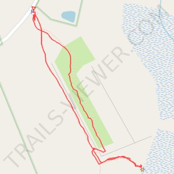
Loop walk at Bennett Wildlife Management Area
- Distance: 1.4 Km
- Elevation gain: 23 m
- Maximum elevation: 268 m
- Elevation loss: 23 m
- Minimum elevation: 245 m
- Moving time: 31 m 51 s
- Moving speed: 2.6 Km/h
- Maximum speed: 5.5 Km/h
- Total time: 44 m 33 s
- Global speed: 1.9 Km/h
Interactive trail map
Make a donation
Gear up for your next adventure:
As an Amazon Associate, this site earns from qualifying purchases at no extra cost to you.
Trail profile
- Distance: 1.4 Km
- Elevation gain: 23 m
- Maximum elevation: 268 m
- Elevation loss: 23 m
- Minimum elevation: 245 m
- Moving time: 31 m 51 s
- Moving speed: 2.6 Km/h
- Maximum speed: 5.5 Km/h
- Total time: 44 m 33 s
- Global speed: 1.9 Km/h
Make a donation
Gear up for your next adventure:
As an Amazon Associate, this site earns from qualifying purchases at no extra cost to you.
About this trail
Name: Loop walk at Bennett Wildlife Management Area trail, distance, elevation, map, profile, GPS track
Start: Gould Road, Charlton, Worcester County, Massachusetts, 01542, United States (42.18713 -71.94404)
End: Gould Road, Charlton, Worcester County, Massachusetts, 01542, United States (42.18722 -71.94409)
Coordinates: 42.18333 -71.94414 42.18733 -71.94045
Make a donation
Gear up for your next adventure:
As an Amazon Associate, this site earns from qualifying purchases at no extra cost to you.
Other hiking, mountain biking, running and outdoor activity trails
Click on a trail to view its statistics, map and profile.
Walk to Cellar Hole at Bennett Wildlife Management Area
United States > Massachusetts > Worcester County > Charlton
Distance: 3.0 Km • Elevation gain: 49 m • Maximum elevation: 268 m