Thank you for supporting this site ❤️
Make a donation
Make a donation
Gear up for your next adventure:
As an Amazon Associate, this site earns from qualifying purchases at no extra cost to you.
Bedford Peak
Interactive trail map
Thank you for supporting this site ❤️
Make a donation
Make a donation
Gear up for your next adventure:
As an Amazon Associate, this site earns from qualifying purchases at no extra cost to you.
Trail profile
- Distance: 5.8 Km
- Elevation gain: 626 m
- Maximum elevation: 1,143 m
- Elevation loss: 60 m
- Minimum elevation: 572 m
Thank you for supporting this site ❤️
Make a donation
Make a donation
Gear up for your next adventure:
As an Amazon Associate, this site earns from qualifying purchases at no extra cost to you.
About this trail
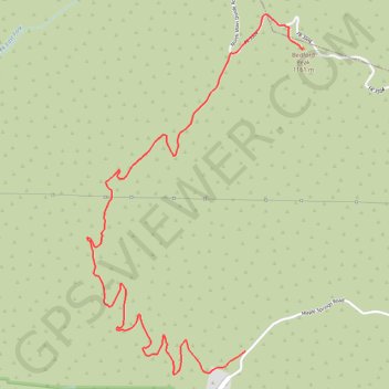
Name: Bedford Peak trail, distance, elevation, map, profile, GPS track
Start: Silverado Motorway, Orange County, California, United States (33.74920 -117.58203)
End: North Main Divide Road, Riverside County, California, United States (33.76687 -117.57799)
Coordinates: 33.74784 -117.59319 33.76895 -117.57799
Thank you for supporting this site ❤️
Make a donation
Make a donation
Gear up for your next adventure:
As an Amazon Associate, this site earns from qualifying purchases at no extra cost to you.