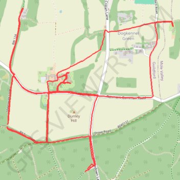
Whitedown & Dog Kennel Green loop
- Distance: 10.0 Km
- Elevation gain: 135 m
- Maximum elevation: 218 m
- Elevation loss: 130 m
- Minimum elevation: 170 m
- Moving time: 1 h 6 m
- Moving speed: 9.0 Km/h
- Maximum speed: 14.6 Km/h
- Total time: 1 h 9 m
- Global speed: 8.6 Km/h
Interactive trail map
Trail profile
- Distance: 10.0 Km
- Elevation gain: 135 m
- Maximum elevation: 218 m
- Elevation loss: 130 m
- Minimum elevation: 170 m
- Moving time: 1 h 6 m
- Moving speed: 9.0 Km/h
- Maximum speed: 14.6 Km/h
- Total time: 1 h 9 m
- Global speed: 8.6 Km/h
About this trail
Name: Whitedown & Dog Kennel Green loop trail, distance, elevation, map, profile, GPS track
Start: Whitedown Lane, Wotton, Mole Valley, Surrey, England, RH5 6SL, United Kingdom (51.23354 -0.40448)
Coordinates: 51.23310 -0.41447 51.24473 -0.39562