Oshara Village park sculptures
sculptures, park
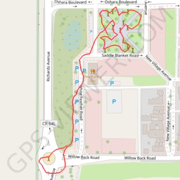
- Distance: 0.6 Km
- Elevation gain: 2 m
- Maximum elevation: 2,005 m
- Elevation loss: 4 m
- Minimum elevation: 2,000 m
- Moving time: 12 m 11 s
- Moving speed: 3.1 Km/h
- Maximum speed: 6.9 Km/h
- Total time: 17 m 48 s
- Global speed: 2.1 Km/h
Interactive trail map
Trail profile
- Distance: 0.6 Km
- Elevation gain: 2 m
- Maximum elevation: 2,005 m
- Elevation loss: 4 m
- Minimum elevation: 2,000 m
- Moving time: 12 m 11 s
- Moving speed: 3.1 Km/h
- Maximum speed: 6.9 Km/h
- Total time: 17 m 48 s
- Global speed: 2.1 Km/h
About this trail
Name: Oshara Village park sculptures trail, distance, elevation, map, profile, GPS track
End: Richards Avenue, Santa Fe County, New Mexico, 87057, United States (35.61188 -106.00024)
Coordinates: 35.61153 -106.00068 35.61362 -105.99910