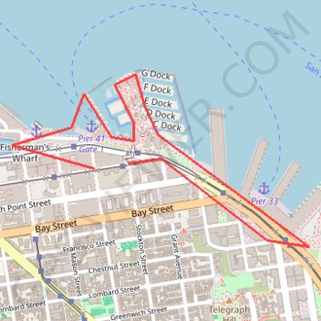
SF Pier 39
- Distance: 3.4 Km
- Elevation gain: 7 m
- Maximum elevation: 6 m
- Elevation loss: 8 m
- Minimum elevation: 0 m
Interactive trail map
Trail profile
- Distance: 3.4 Km
- Elevation gain: 7 m
- Maximum elevation: 6 m
- Elevation loss: 8 m
- Minimum elevation: 0 m
About this trail
Name: SF Pier 39 trail, distance, elevation, map, profile, GPS track
Coordinates: 37.80474 -122.41633 37.81133 -122.40200
Other hiking, mountain biking, running and outdoor activity trails
Click on a trail to view its statistics, map and profile.
San Francisco MTB Loop
United States > California > San Francisco
Mountain Bike in San Francisco via Fisherman's Warf, Marina District, Presidio, Golden Gate Bridge, Marin Headlands, Baker Beach, Lincoln Park, Land's End, Ocean Beach, Golden Gate Park, Haight Ashbury, The Mission, Japantown, Pacific Heights and Lombard Street. #MTB #Loop #City #Pacific #Ocean #Sea #Forest…
Distance: 48.8 Km • Elevation gain: 952 m • Maximum elevation: 175 m