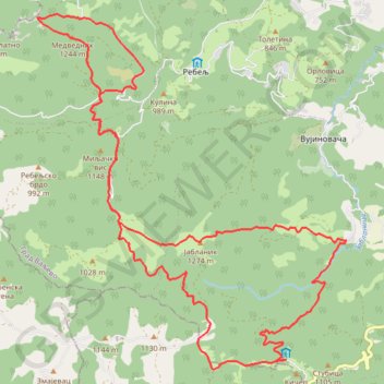
Jablanik i Medvednik
- Distance: 27.8 Km
- Elevation gain: 1,524 m
- Maximum elevation: 1,269 m
- Elevation loss: 1,526 m
- Minimum elevation: 601 m
- Moving time: 8 h 42 m
- Moving speed: 3.2 Km/h
- Maximum speed: 5.6 Km/h
- Total time: 9 h 15 m
- Global speed: 3.0 Km/h
Interactive trail map
Trail profile
- Distance: 27.8 Km
- Elevation gain: 1,524 m
- Maximum elevation: 1,269 m
- Elevation loss: 1,526 m
- Minimum elevation: 601 m
- Moving time: 8 h 42 m
- Moving speed: 3.2 Km/h
- Maximum speed: 5.6 Km/h
- Total time: 9 h 15 m
- Global speed: 3.0 Km/h
About this trail
Name: Jablanik i Medvednik trail, distance, elevation, map, profile, GPS track
Coordinates: 44.15548 19.62952 44.21381 19.70027
Other hiking, mountain biking, running and outdoor activity trails
Click on a trail to view its statistics, map and profile.
Kanjon Sušice
Serbia > Central Serbia > Macva Administrative District > Ljubovija Municipality > Savkovic
Distance: 17.3 Km • Elevation gain: 506 m • Maximum elevation: 1,093 m
2022_Yu
Slovenia > Ajdovščina > Žapuže
Distance: 2,457.3 Km • Elevation gain: 32,048 m • Maximum elevation: 1,950 m