Atalaya Trail in Santa Fe National Forest
The Atalaya Trail is a fantastic hike that offers a delightful mix of woodland and rocky landscapes. As you ascend, you'll be treated to breathtaking views of Santa Fe and the surrounding mountains, with the most stunning panoramas awaiting you at the Atalaya Mountain summit. The trail is well-marked and navigable, making it perfect for both seasoned hikers and those looking for a scenic escape into nature. #Hiking #Mountain #Forest #Nature
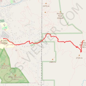
- Distance: 10.1 Km
- Elevation gain: 541 m
- Maximum elevation: 2,769 m
- Elevation loss: 541 m
- Minimum elevation: 2,235 m
- Moving time: 2 h 19 m
- Moving speed: 4.4 Km/h
- Maximum speed: 6.6 Km/h
- Total time: 2 h 32 m
- Global speed: 4.0 Km/h
Interactive trail map
Trail profile
- Distance: 10.1 Km
- Elevation gain: 541 m
- Maximum elevation: 2,769 m
- Elevation loss: 541 m
- Minimum elevation: 2,235 m
- Moving time: 2 h 19 m
- Moving speed: 4.4 Km/h
- Maximum speed: 6.6 Km/h
- Total time: 2 h 32 m
- Global speed: 4.0 Km/h
About this trail
Name: Atalaya Trail in Santa Fe National Forest trail, distance, elevation, map, profile, GPS track
Coordinates: 35.66342 -105.91273 35.67034 -105.87636