Thank you for supporting this site ❤️
Make a donation
Make a donation
Gear up for your next adventure:
As an Amazon Associate, this site earns from qualifying purchases at no extra cost to you.
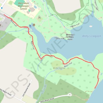
Witty's Lagoon Beach Trail
Vancouver Island. Witty's Lagoon Regional Park. #Hiking #Loop #Vancouver #WittysLagoon
- Distance: 2.5 Km
- Elevation gain: 61 m
- Maximum elevation: 47 m
- Elevation loss: 61 m
- Minimum elevation: 0 m
Interactive trail map
Thank you for supporting this site ❤️
Make a donation
Make a donation
Gear up for your next adventure:
As an Amazon Associate, this site earns from qualifying purchases at no extra cost to you.
Trail profile
- Distance: 2.5 Km
- Elevation gain: 61 m
- Maximum elevation: 47 m
- Elevation loss: 61 m
- Minimum elevation: 0 m
Thank you for supporting this site ❤️
Make a donation
Make a donation
Gear up for your next adventure:
As an Amazon Associate, this site earns from qualifying purchases at no extra cost to you.
About this trail
Name: Witty's Lagoon Beach Trail trail, distance, elevation, map, profile, GPS track
Coordinates: 48.38379 -123.52531 48.38925 -123.51474
Topography: Capital Regional District topographic map, elevation, terrain
Thank you for supporting this site ❤️
Make a donation
Make a donation
Gear up for your next adventure:
As an Amazon Associate, this site earns from qualifying purchases at no extra cost to you.
Other hiking, mountain biking, running and outdoor activity trails
Click on a trail to view its statistics, map and profile.