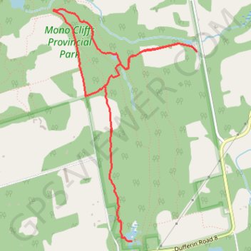
Mono Cliffs Provincial Park Loop
#Hiking #MTB #Loop #MonoCliffs
- Distance: 8.1 Km
- Elevation gain: 157 m
- Maximum elevation: 492 m
- Elevation loss: 157 m
- Minimum elevation: 404 m
Interactive trail map
Trail profile
- Distance: 8.1 Km
- Elevation gain: 157 m
- Maximum elevation: 492 m
- Elevation loss: 157 m
- Minimum elevation: 404 m
About this trail
Name: Mono Cliffs Provincial Park Loop trail, distance, elevation, map, profile, GPS track
Coordinates: 44.02928 -80.08031 44.05049 -80.06212
Topography: Dufferin County topographic map, elevation, terrain
Other hiking, mountain biking, running and outdoor activity trails
Click on a trail to view its statistics, map and profile.
McCarston's Lake
Canada > Ontario > Dufferin County > Mono
Mono Cliffs Provincial Park. #Hiking #MTB #Loop #MonoCliffs
Distance: 9.1 Km • Elevation gain: 131 m • Maximum elevation: 503 m
Ontario country roads
Distance: 150.4 Km • Elevation gain: 1,137 m • Maximum elevation: 497 m