Make a donation
Gear up for your next adventure:
As an Amazon Associate, this site earns from qualifying purchases at no extra cost to you.
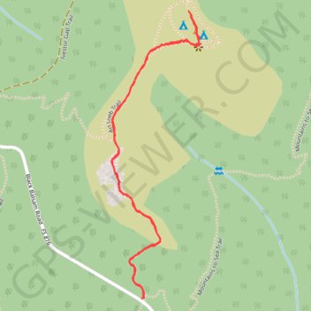
Black Balsam Knob via Art Loeb Trail in Pisgah National Forest
The hike to Black Balsam Knob is a favorite for its sweeping views and unique, treeless balds that stretch along the ridge. As you ascend, grassy fields and open skies create an almost alpine atmosphere, with uninterrupted 360-degree views of the Blue Ridge Mountains surrounding you at the summit. Whether you enjoy a short, scenic climb or extend the trek to neighboring peaks like Tennent Mountain, this trail is known for its breathtaking vistas and serene, high-altitude meadows—a perfect snapshot of North Carolina's rugged beauty. #Hiking #Mountain #Overlook #Forest #Nature
- Distance: 2.4 Km
- Elevation gain: 102 m
- Maximum elevation: 1,886 m
- Elevation loss: 102 m
- Minimum elevation: 1,791 m
- Moving time: 42 m 5 s
- Moving speed: 3.4 Km/h
- Maximum speed: 5.9 Km/h
- Total time: 52 m 30 s
- Global speed: 2.7 Km/h
Interactive trail map
Make a donation
Gear up for your next adventure:
As an Amazon Associate, this site earns from qualifying purchases at no extra cost to you.
Trail profile
- Distance: 2.4 Km
- Elevation gain: 102 m
- Maximum elevation: 1,886 m
- Elevation loss: 102 m
- Minimum elevation: 1,791 m
- Moving time: 42 m 5 s
- Moving speed: 3.4 Km/h
- Maximum speed: 5.9 Km/h
- Total time: 52 m 30 s
- Global speed: 2.7 Km/h
Make a donation
Gear up for your next adventure:
As an Amazon Associate, this site earns from qualifying purchases at no extra cost to you.
About this trail
Name: Black Balsam Knob via Art Loeb Trail in Pisgah National Forest trail, distance, elevation, map, profile, GPS track
Start: Black Balsam Road, Haywood County, North Carolina, United States (35.32068 -82.87622)
End: Mountains-to-Sea Trail, Haywood County, North Carolina, United States (35.32071 -82.87617)
Coordinates: 35.32068 -82.87722 35.32837 -82.87435
Make a donation
Gear up for your next adventure:
As an Amazon Associate, this site earns from qualifying purchases at no extra cost to you.