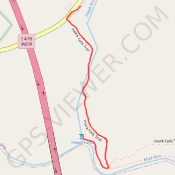
Hawk Falls Trail in Hickory Run State Park
Hawk Falls Trail offers a delightful hiking experience characterized by its diverse natural scenery and the enchanting 25-foot waterfall at the trail's end. As you traverse the moderately easy path, you'll encounter picturesque views of Mud Run and Panther Creek, along with striking rock formations and lush forest surroundings. This family-friendly trail is perfect for those looking to immerse themselves in the beauty of the Poconos, making it a popular choice for hikers of all ages. #Hiking #Waterfall #Forest #Nature
- Distance: 1.9 Km
- Elevation gain: 46 m
- Maximum elevation: 458 m
- Elevation loss: 44 m
- Minimum elevation: 419 m
- Moving time: 32 m 5 s
- Moving speed: 3.6 Km/h
- Maximum speed: 5.5 Km/h
- Total time: 37 m 24 s
- Global speed: 3.1 Km/h
Interactive trail map
Trail profile
- Distance: 1.9 Km
- Elevation gain: 46 m
- Maximum elevation: 458 m
- Elevation loss: 44 m
- Minimum elevation: 419 m
- Moving time: 32 m 5 s
- Moving speed: 3.6 Km/h
- Maximum speed: 5.5 Km/h
- Total time: 37 m 24 s
- Global speed: 3.1 Km/h
About this trail
Name: Hawk Falls Trail in Hickory Run State Park trail, distance, elevation, map, profile, GPS track
End: PA 534, Kidder Township, Carbon County, Pennsylvania, United States (41.01052 -75.63442)
Coordinates: 41.00472 -75.63467 41.01076 -75.63258