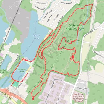
Minehill NJ: Dickerson Mine Preserve loop trails
Morning Trail Loop Run
- Distance: 12.3 Km
- Elevation gain: 211 m
- Maximum elevation: 289 m
- Elevation loss: 210 m
- Minimum elevation: 210 m
- Moving time: 1 h 15 m
- Moving speed: 9.8 Km/h
- Maximum speed: 14.0 Km/h
- Total time: 1 h 15 m
- Global speed: 9.8 Km/h
Interactive trail map
Trail profile
- Distance: 12.3 Km
- Elevation gain: 211 m
- Maximum elevation: 289 m
- Elevation loss: 210 m
- Minimum elevation: 210 m
- Moving time: 1 h 15 m
- Moving speed: 9.8 Km/h
- Maximum speed: 14.0 Km/h
- Total time: 1 h 15 m
- Global speed: 9.8 Km/h
About this trail
Name: Minehill NJ: Dickerson Mine Preserve loop trails trail, distance, elevation, map, profile, GPS track
Start: Green Lane, Randolph Township, Morris County, New Jersey, 07847, United States (40.86251 -74.62504)
End: Green Lane, Randolph Township, Morris County, New Jersey, 07847, United States (40.86212 -74.62539)
Coordinates: 40.85974 -74.62539 40.87548 -74.60783