Make a donation
Gear up for your next adventure:
As an Amazon Associate, this site earns from qualifying purchases at no extra cost to you.
New
- Distance: 54.9 Km
- Elevation gain: 1,385 m
- Maximum elevation: 364 m
- Elevation loss: 1,382 m
- Minimum elevation: -2 m
Interactive trail map
Make a donation
Gear up for your next adventure:
As an Amazon Associate, this site earns from qualifying purchases at no extra cost to you.
Trail profile
- Distance: 54.9 Km
- Elevation gain: 1,385 m
- Maximum elevation: 364 m
- Elevation loss: 1,382 m
- Minimum elevation: -2 m
Make a donation
Gear up for your next adventure:
As an Amazon Associate, this site earns from qualifying purchases at no extra cost to you.
About this trail
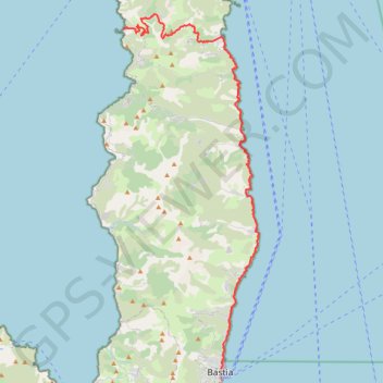
Name: New trail, distance, elevation, map, profile, GPS track
Coordinates: 42.70178 9.34967 42.97665 9.49227
Make a donation
Gear up for your next adventure:
As an Amazon Associate, this site earns from qualifying purchases at no extra cost to you.
Other hiking, mountain biking, running and outdoor activity trails
Click on a trail to view its statistics, map and profile.
1 LUCENA - MONTPELLIER
Distance: 2,964.4 Km • Elevation gain: 29,500 m • Maximum elevation: 1,048 m
New
France > Corsica > Haute-Corse > Bastia
Distance: 69.8 Km • Elevation gain: 1,803 m • Maximum elevation: 364 m
New
France > Corsica > Haute-Corse > Port de Centuri
Distance: 58.6 Km • Elevation gain: 2,161 m • Maximum elevation: 203 m
New
France > Corsica > Haute-Corse > Port de Centuri
Distance: 62.9 Km • Elevation gain: 2,375 m • Maximum elevation: 240 m
Make a donation
Gear up for your next adventure:
As an Amazon Associate, this site earns from qualifying purchases at no extra cost to you.