Make a donation
Gear up for your next adventure:
As an Amazon Associate, this site earns from qualifying purchases at no extra cost to you.
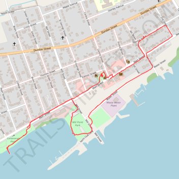
Walk - Deseronto
Canada, ON, Deseronto
- Distance: 3.7 Km
- Elevation gain: 33 m
- Maximum elevation: 91 m
- Elevation loss: 30 m
- Minimum elevation: 74 m
- Moving time: 1 h 4 m
- Moving speed: 3.5 Km/h
- Maximum speed: 4.8 Km/h
- Total time: 1 h 23 m
- Global speed: 2.7 Km/h
Interactive trail map
Make a donation
Gear up for your next adventure:
As an Amazon Associate, this site earns from qualifying purchases at no extra cost to you.
Trail profile
- Distance: 3.7 Km
- Elevation gain: 33 m
- Maximum elevation: 91 m
- Elevation loss: 30 m
- Minimum elevation: 74 m
- Moving time: 1 h 4 m
- Moving speed: 3.5 Km/h
- Maximum speed: 4.8 Km/h
- Total time: 1 h 23 m
- Global speed: 2.7 Km/h
Make a donation
Gear up for your next adventure:
As an Amazon Associate, this site earns from qualifying purchases at no extra cost to you.
About this trail
Name: Walk - Deseronto trail, distance, elevation, map, profile, GPS track
End: 180, Main Street, Deseronto, Hastings County, Central Ontario, Ontario, Canada (44.19207 -77.05511)
Coordinates: 44.19054 -77.05678 44.19814 -77.04311
Topography: Hastings County topographic map, elevation, terrain
Make a donation
Gear up for your next adventure:
As an Amazon Associate, this site earns from qualifying purchases at no extra cost to you.
Other hiking, mountain biking, running and outdoor activity trails
Click on a trail to view its statistics, map and profile.
Belleville - Kingston
Canada > Ontario > Belleville > Belleville
#Bike
Distance: 92.7 Km • Elevation gain: 394 m • Maximum elevation: 115 m