Make a donation
Gear up for your next adventure:
As an Amazon Associate, this site earns from qualifying purchases at no extra cost to you.
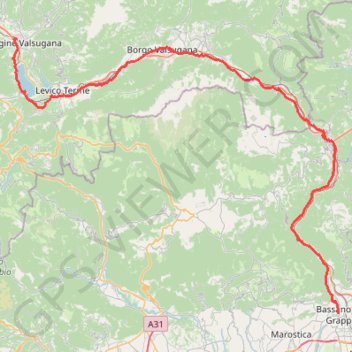
Itinerario della Valsugana by PisteCiclabili.com
- Distance: 83.8 Km
- Elevation gain: 819 m
- Maximum elevation: 493 m
- Elevation loss: 1,171 m
- Minimum elevation: 110 m
Interactive trail map
Make a donation
Gear up for your next adventure:
As an Amazon Associate, this site earns from qualifying purchases at no extra cost to you.
Trail profile
- Distance: 83.8 Km
- Elevation gain: 819 m
- Maximum elevation: 493 m
- Elevation loss: 1,171 m
- Minimum elevation: 110 m
Make a donation
Gear up for your next adventure:
As an Amazon Associate, this site earns from qualifying purchases at no extra cost to you.
About this trail
Name: Itinerario della Valsugana by PisteCiclabili.com trail, distance, elevation, map, profile, GPS track
Coordinates: 45.76749 11.22569 46.06457 11.73119
Make a donation
Gear up for your next adventure:
As an Amazon Associate, this site earns from qualifying purchases at no extra cost to you.
Other hiking, mountain biking, running and outdoor activity trails
Click on a trail to view its statistics, map and profile.
Riva del Garda - Pergine Valsugana
Italy > Trentino – Alto Adige/Südtirol > Provincia di Trento > Riva del Garda > Sant'Alessandro > Alboletta
One-way between Riva del Garda and Pergine Valsugana.
Distance: 193.3 Km • Elevation gain: 5,511 m • Maximum elevation: 2,038 m