Make a donation
Gear up for your next adventure:
As an Amazon Associate, this site earns from qualifying purchases at no extra cost to you.
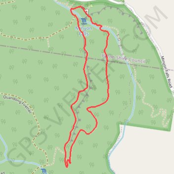
Minyon Falls Loop
Interactive trail map
Make a donation
Gear up for your next adventure:
As an Amazon Associate, this site earns from qualifying purchases at no extra cost to you.
Trail profile
- Distance: 3.7 Km
- Elevation gain: 298 m
- Maximum elevation: 344 m
- Elevation loss: 298 m
- Minimum elevation: 175 m
Make a donation
Gear up for your next adventure:
As an Amazon Associate, this site earns from qualifying purchases at no extra cost to you.
About this trail
Name: Minyon Falls Loop trail, distance, elevation, map, profile, GPS track
Start: Minyon Loop, Byron Shire Council, New South Wales, Australia (-28.61193 153.38959)
End: Minyon Loop, Byron Shire Council, New South Wales, Australia (-28.61193 153.38959)
Coordinates: -28.62455 153.38817 -28.61193 153.39212
Make a donation
Gear up for your next adventure:
As an Amazon Associate, this site earns from qualifying purchases at no extra cost to you.
Other hiking, mountain biking, running and outdoor activity trails
Click on a trail to view its statistics, map and profile.
Gidjuum Gulganyi Complete
Australia > New South Wales > Chowan Creek
Distance: 42.2 Km • Elevation gain: 1,878 m • Maximum elevation: 821 m