Thank you for supporting this site ❤️
Make a donation
Make a donation
Gear up for your next adventure:
As an Amazon Associate, this site earns from qualifying purchases at no extra cost to you.
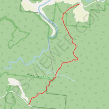
Bump Track
Interactive trail map
Thank you for supporting this site ❤️
Make a donation
Make a donation
Gear up for your next adventure:
As an Amazon Associate, this site earns from qualifying purchases at no extra cost to you.
Trail profile
- Distance: 12.1 Km
- Elevation gain: 427 m
- Maximum elevation: 393 m
- Elevation loss: 427 m
- Minimum elevation: 25 m
Thank you for supporting this site ❤️
Make a donation
Make a donation
Gear up for your next adventure:
As an Amazon Associate, this site earns from qualifying purchases at no extra cost to you.
About this trail
Name: Bump Track trail, distance, elevation, map, profile, GPS track
Start: Connolly Road, Mowbray, Douglas Shire, Queensland, Australia (-16.56653 145.45443)
End: Connolly Road, Mowbray, Douglas Shire, Queensland, Australia (-16.56653 145.45443)
Coordinates: -16.60275 145.43502 -16.56653 145.45443
Thank you for supporting this site ❤️
Make a donation
Make a donation
Gear up for your next adventure:
As an Amazon Associate, this site earns from qualifying purchases at no extra cost to you.