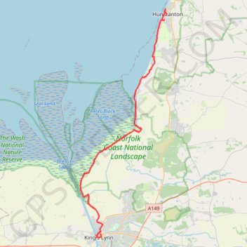
Hunstanton to Kings Lynn
Norfolk Coast Path/England Coast Path
- Distance: 31.2 Km
- Elevation gain: 90 m
- Maximum elevation: 25 m
- Elevation loss: 105 m
- Minimum elevation: -2 m
- Moving time: 6 h 38 m
- Moving speed: 4.7 Km/h
- Maximum speed: 14.8 Km/h
- Total time: 7 h 40 m
- Global speed: 4.1 Km/h
Interactive trail map
Trail profile
- Distance: 31.2 Km
- Elevation gain: 90 m
- Maximum elevation: 25 m
- Elevation loss: 105 m
- Minimum elevation: -2 m
- Moving time: 6 h 38 m
- Moving speed: 4.7 Km/h
- Maximum speed: 14.8 Km/h
- Total time: 7 h 40 m
- Global speed: 4.1 Km/h
About this trail
Name: Hunstanton to Kings Lynn trail, distance, elevation, map, profile, GPS track
Coordinates: 52.75341 0.37057 52.94325 0.48901
Other hiking, mountain biking, running and outdoor activity trails
Click on a trail to view its statistics, map and profile.
Norfolk Coast Path - Dersingham to Hunstanton
United Kingdom > England > Norfolk > King's Lynn and West Norfolk > Dersingham
Distance: 18.4 Km • Elevation gain: 59 m • Maximum elevation: 24 m
Norfolk Coast Path - King's Lynn to Dersingham
United Kingdom > England > Norfolk > King's Lynn and West Norfolk > King's Lynn
Distance: 21.0 Km • Elevation gain: 54 m • Maximum elevation: 14 m
The Wash National Nature Reserve
United Kingdom > England > Norfolk > King's Lynn and West Norfolk > West Lynn
walking, norfolk-coast-path, west-lynn
Distance: 21.1 Km • Elevation gain: 61 m • Maximum elevation: 6 m