Import a GPX file

Seven Sisters Prairie Loop Trail

  • Distance: 1.5 Km
  • Elevation gain: 49 m
  • Maximum elevation: 424 m
  • Elevation loss: 51 m
  • Minimum elevation: 376 m
  • Moving time: 22 m 19 s
  • Moving speed: 4.0 Km/h
  • Maximum speed: 11.3 Km/h
  • Total time: 26 m 2 s
  • Global speed: 3.4 Km/h

Interactive trail map

Trail profile

  • Distance: 1.5 Km
  • Elevation gain: 49 m
  • Maximum elevation: 424 m
  • Elevation loss: 51 m
  • Minimum elevation: 376 m
  • Moving time: 22 m 19 s
  • Moving speed: 4.0 Km/h
  • Maximum speed: 11.3 Km/h
  • Total time: 26 m 2 s
  • Global speed: 3.4 Km/h

About this trail
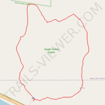
Name: Seven Sisters Prairie Loop Trail trail, distance, elevation, map, profile, GPS track

Start: Minnesota State Highway 78, Ashby, Douglas County, Minnesota, 56309, United States (46.10658 -95.74553)

End: Minnesota State Highway 78, Ashby, Douglas County, Minnesota, 56309, United States (46.10637 -95.74548)

Coordinates: 46.10637 -95.74654 46.11057 -95.74202

Gear up for your next adventure:

🛶Kayak Dry Bag - Waterproof storage for kayaking adventures
🧴Insect Repellent - Protect yourself from bugs during outdoor adventures
🦌Outdoor Trail Camera - Monitor wildlife activity near your favorite spots
🥾Light Hiking Boots - Lightweight and comfortable boots for day hikes
🥾Hiking Shoes - Durable and comfortable shoes for trail hiking

As an Amazon Associate, this site earns from qualifying purchases at no extra cost to you.