Munds Wagon Trail and Hangover Trail Loop in Coconino National Forest
The Munds Wagon and Hangover Trail Loop in Coconino National Forest offers a stunning journey through Sedona's famous red rock landscape. The hike provides panoramic views of towering formations like Teapot Rock and Queen Victoria, along with dramatic vistas over Bear Wallow Canyon and the surrounding valleys. Expect a challenging mix of rocky terrain, switchbacks, and light scrambling, especially along the Hangover Trail, where you’ll follow cliffside paths with breathtaking drop-offs. #Hiking #Mountain #Rock #Nature #Loop #Forest #Canyon
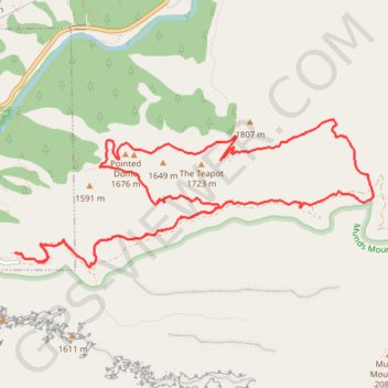
- Distance: 13.3 Km
- Elevation gain: 391 m
- Maximum elevation: 1,595 m
- Elevation loss: 393 m
- Minimum elevation: 1,357 m
- Moving time: 3 h 39 m
- Moving speed: 3.6 Km/h
- Maximum speed: 5.9 Km/h
- Total time: 4 h 19 m
- Global speed: 3.1 Km/h
Interactive trail map
Trail profile
- Distance: 13.3 Km
- Elevation gain: 391 m
- Maximum elevation: 1,595 m
- Elevation loss: 393 m
- Minimum elevation: 1,357 m
- Moving time: 3 h 39 m
- Moving speed: 3.6 Km/h
- Maximum speed: 5.9 Km/h
- Total time: 4 h 19 m
- Global speed: 3.1 Km/h
About this trail
Name: Munds Wagon Trail and Hangover Trail Loop in Coconino National Forest trail, distance, elevation, map, profile, GPS track
End: Munds Wagon Trail, Sedona, Coconino County, Arizona, United States (34.86669 -111.74861)
Coordinates: 34.86551 -111.74896 34.87771 -111.71285