Make a donation
Gear up for your next adventure:
As an Amazon Associate, this site earns from qualifying purchases at no extra cost to you.
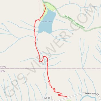
Lena Lake Trail in Olympic National Forest
The Lena Lake Trail in the Olympic National Forest offers a serene hiking experience through lush, old-growth forests, with stretches of vibrant rhododendron blooms during late spring. As you climb toward the lake, you'll encounter views of moss-covered trees, trickling streams, and the tranquil waters of Lena Lake, which provides a picturesque setting for a restful break. For those seeking to extend their adventure, the route continues into the rugged Valley of Silent Men or further to Upper Lena Lake, offering more challenging terrain and expansive views of the surrounding wilderness. #Hiking #Mountain #Forest #Nature #Lake
- Distance: 8.2 Km
- Elevation gain: 524 m
- Maximum elevation: 618 m
- Elevation loss: 524 m
- Minimum elevation: 218 m
Interactive trail map
Make a donation
Gear up for your next adventure:
As an Amazon Associate, this site earns from qualifying purchases at no extra cost to you.
Trail profile
- Distance: 8.2 Km
- Elevation gain: 524 m
- Maximum elevation: 618 m
- Elevation loss: 524 m
- Minimum elevation: 218 m
Make a donation
Gear up for your next adventure:
As an Amazon Associate, this site earns from qualifying purchases at no extra cost to you.
About this trail
Name: Lena Lake Trail in Olympic National Forest trail, distance, elevation, map, profile, GPS track
Coordinates: 47.59977 -123.16435 47.62450 -123.15147
Make a donation
Gear up for your next adventure:
As an Amazon Associate, this site earns from qualifying purchases at no extra cost to you.
Other hiking, mountain biking, running and outdoor activity trails
Click on a trail to view its statistics, map and profile.
Lena Lake Trail in Olympic National Forest
United States > Washington > Mason County
The Lena Lake Trail in the Olympic National Forest offers hikers a peaceful yet moderately challenging adventure, marked by stunning natural features. Along the route, you'll pass through lush forests filled with moss-covered trees and cross multiple creeks, with a few charming bridges that enhance the…
Distance: 9.7 Km • Elevation gain: 559 m • Maximum elevation: 622 m