Make a donation
Gear up for your next adventure:
As an Amazon Associate, this site earns from qualifying purchases at no extra cost to you.
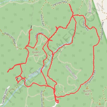
Garfield Water Wheel, Garfield mine, Quartz Hill and Goldfields track walk
- Distance: 9.9 Km
- Elevation gain: 261 m
- Maximum elevation: 413 m
- Elevation loss: 261 m
- Minimum elevation: 328 m
- Moving time: 2 h 31 m
- Moving speed: 3.9 Km/h
- Maximum speed: 6.6 Km/h
- Total time: 3 h 32 m
- Global speed: 2.8 Km/h
Interactive trail map
Make a donation
Gear up for your next adventure:
As an Amazon Associate, this site earns from qualifying purchases at no extra cost to you.
Trail profile
- Distance: 9.9 Km
- Elevation gain: 261 m
- Maximum elevation: 413 m
- Elevation loss: 261 m
- Minimum elevation: 328 m
- Moving time: 2 h 31 m
- Moving speed: 3.9 Km/h
- Maximum speed: 6.6 Km/h
- Total time: 3 h 32 m
- Global speed: 2.8 Km/h
Make a donation
Gear up for your next adventure:
As an Amazon Associate, this site earns from qualifying purchases at no extra cost to you.
About this trail
Name: Garfield Water Wheel, Garfield mine, Quartz Hill and Goldfields track walk trail, distance, elevation, map, profile, GPS track
Start: Chewton, Victoria, 3451, Australia (-37.07284 144.25970)
End: Chewton, Victoria, 3451, Australia (-37.07284 144.25968)
Coordinates: -37.07292 144.25183 -37.06069 144.26605
Make a donation
Gear up for your next adventure:
As an Amazon Associate, this site earns from qualifying purchases at no extra cost to you.
Other hiking, mountain biking, running and outdoor activity trails
Click on a trail to view its statistics, map and profile.
Quartz Hill, Garfield WW and Goldfields Track walk
Australia > Victoria > Castlemaine
Distance: 7.9 Km • Elevation gain: 147 m • Maximum elevation: 393 m
Quartz Hill, Quartz Hill mine, sailors Gully and Goldfields Track
Australia > Victoria > Castlemaine
Distance: 7.2 Km • Elevation gain: 132 m • Maximum elevation: 393 m
Castlemaine Diggins Park and Kalimns Park Loop
Loop hike via Pikestreet Road, The Folly Track, Welsh Street, Forest Creek Track, Expedition Pass Reservoir, Nicholson Extension Track, No 1 Remote Track, Haws No 1 Track, North West Break and Unknown Miners Grave in the Castlemaine Diggins National Heritage Park and the Kalimns Park. #Hiking #Loop #Nature…
Distance: 11.7 Km • Elevation gain: 256 m • Maximum elevation: 433 m
Specimen Gully, Pineys, Golden Point Res, Garfield Water Wheel, Chewton, Castlemaine, Botanic gardens walk
Distance: 18.3 Km • Elevation gain: 269 m • Maximum elevation: 468 m
Make a donation
Gear up for your next adventure:
As an Amazon Associate, this site earns from qualifying purchases at no extra cost to you.