Thank you for supporting this site ❤️
Make a donation
Make a donation
Gear up for your next adventure:
As an Amazon Associate, this site earns from qualifying purchases at no extra cost to you.
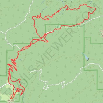
Tum Tum and Marys Peak
- Distance: 36.2 Km
- Elevation gain: 1,650 m
- Maximum elevation: 1,241 m
- Elevation loss: 1,651 m
- Minimum elevation: 272 m
- Moving time: 4 h 38 m
- Moving speed: 7.8 Km/h
- Maximum speed: 15.8 Km/h
- Total time: 4 h 52 m
- Global speed: 7.4 Km/h
Interactive trail map
Thank you for supporting this site ❤️
Make a donation
Make a donation
Gear up for your next adventure:
As an Amazon Associate, this site earns from qualifying purchases at no extra cost to you.
Trail profile
- Distance: 36.2 Km
- Elevation gain: 1,650 m
- Maximum elevation: 1,241 m
- Elevation loss: 1,651 m
- Minimum elevation: 272 m
- Moving time: 4 h 38 m
- Moving speed: 7.8 Km/h
- Maximum speed: 15.8 Km/h
- Total time: 4 h 52 m
- Global speed: 7.4 Km/h
Thank you for supporting this site ❤️
Make a donation
Make a donation
Gear up for your next adventure:
As an Amazon Associate, this site earns from qualifying purchases at no extra cost to you.
About this trail
Name: Tum Tum and Marys Peak trail, distance, elevation, map, profile, GPS track
Start: Woods Creek Road, Benton County, Oregon, United States (44.54498 -123.49927)
End: Woods Creek Road, Benton County, Oregon, United States (44.54507 -123.49907)
Coordinates: 44.50372 -123.55578 44.55629 -123.48697
Thank you for supporting this site ❤️
Make a donation
Make a donation
Gear up for your next adventure:
As an Amazon Associate, this site earns from qualifying purchases at no extra cost to you.